Home Home

 
Index...

Search this site:
Arts School, Ford Street
Bishop Street Post Office
Bishop Street, looking north
Bishop Street, looking south
Blue Coat School & ruins
Broadgate from Hertford Street
Broadgate from Holy Trinity Church
Burges from Bishop Street
Burges from Cross Cheaping
Burton's in Blitzed Broadgate
Butcher Row, Great
Butcher Row, Little
Cheylesmore Manor House
Coat of Arms Bridge
Cook Street gate
Council House
Cox Street
Far Gosford Street
Fire Station, Hales Street
Fleet Street
Ford's Hospital
Golden Cross & Pepper Lane
Greyfriars Lane
The Grove
Guildhall & 22 Bayley Lane
Hales Street
Hales Street to Corporation Street
Herbert Art Gallery & Museum
Hertford Street
Hertford Street from Broadgate
High Street aerial view
High Street from Broadgate
High Street from Earl Street
Hill Street, Bablake & Bond's
Hippodrome, New
Hippodrome, Old
Humber Motor Works
Ironmonger Row
Jordan Well & Earl Street
Jordan Well & Gosford Street
Kenilworth Road
Leamington Road
Much Park Street
Naul's Mill Park
Old Rope Walk
Opera House, Hales Street
Palace Yard
Pool Meadow from Priory Street
Precinct & Old Coventry aerial view
Precinct, upper
Precinct, west view
Priory Row
Priory Street, lower end
Priory Street, upper end
Queen Victoria Road flood of 1900
Railway Station - the platform
Railway Station, Eaton Road
Smithford Way
Spon End arches
Spon Street flood of 1900
St. John's Church, Fleet Street
St. Michael's Avenue
St. Michael's ruins
St. Michael's spire from Pepper Lane
Stoke Green & Pool
Swanswell Gate
Swanswell Pool
Swimming Baths, Priory Street
Trinity Church aerial view
Trinity Lane & the Free Library
Trinity Lane from Priory Row
Trinity Street aerial view
Trinity Street from Broadgate
Trinity Street from Hales Street
War Memorial Park
Warwick Road
Warwick Row, Hertford St & Warwick Lane
Well Street from Hales Street
West Orchard
Wheatley Street Schools
 

The Grove

Camera No. 78

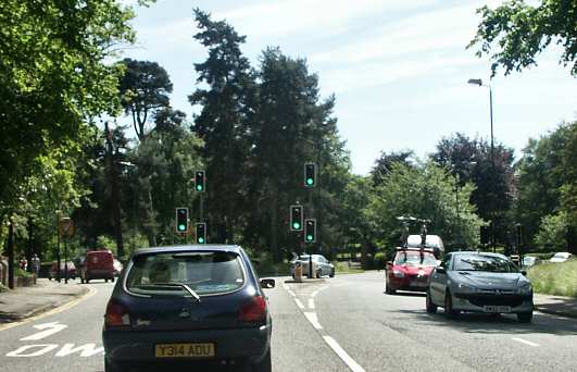
The first of this pleasant pair of photographs was taken from a postcard used in 1921 - the same year that the ground beyond, formerly Stivichall Common, was used to build the War Memorial Park at the point where the Warwick Road splits into the Leamington Road on the left and the Kenilworth Road on the right. Although still a comparatively rural scene, the traffic does rather spoil the modern day view, which was taken on the way to that park.
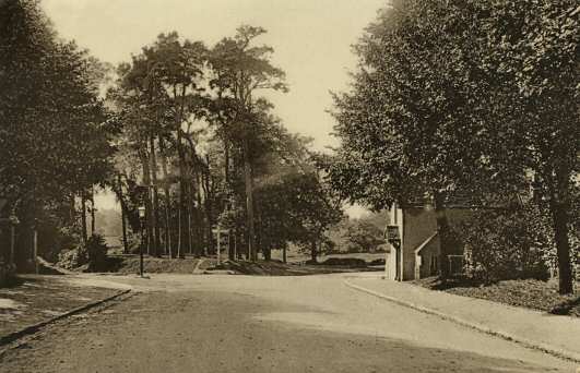
The Grove, Kenilworth Road in 1921
The Grove, Kenilworth Road in 2006

An interesting feature of the older photograph, now sadly gone, is the old Toll House on the right. Just as the M6 Toll Road operates today, it was common for better quality roads in the 18th and 19th centuries to be built by groups of wealthy people - but with a charge for usage. By the 1860s as trains were becoming popular, toll gates, also known as turnpikes, became less desirable, and were phased out. This Stivichall toll house was one of the last in the area to stop operating in 1872, although it was still standing after the Second World War, but later demolished as the roads were widened.

If you were to stand at the Grove and look back in this direction, towards the town centre, this is the view of Warwick Road that you would see.


Associated pages....
Home | How this site began | Bibliography | About me | My music | Discussion Forum | Steve's website | Historic Stoke, Coventry | Orland family website
Top of the page
3,352,638

Website by Rob Orland © 2002 to 2024