The Great Flood of December 1900, and the lost Bridges, by Damien Kimberley
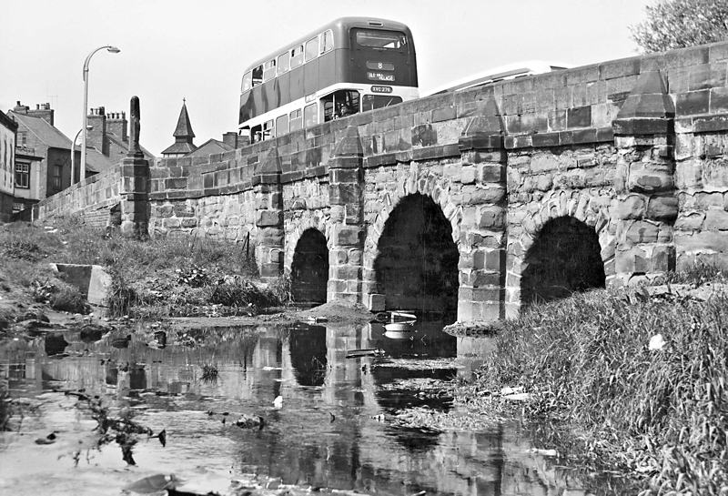
A view of Spon End Bridge from the messy bank of the Sherbourne facing Spon Street towards town. The bus, XVC 276 was registered in 1959 which helps date the image.
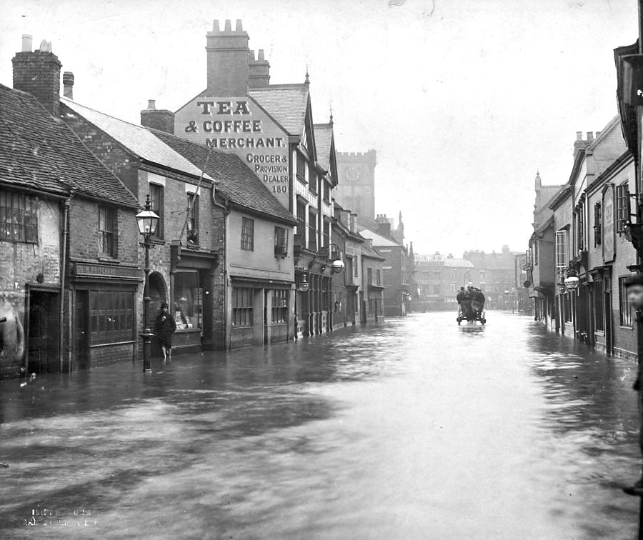
A very wet looking Spon Street looking towards Fleet Street. The man on the left is stood at the entrance to Court 50, his back against the premises of Harry Hopkins, hairdresser. Perhaps he IS harry Hopkins. The children upstairs may well be his, Florence and Syd.
(
Click the image for a larger version.)
 f you were to walk to modern day Meadow Street in Spon End, Coventry, you will find the exact place that the River Sherbourne is culverted underneath the City Centre. If you then make your way to The Burges and head down Palmer Lane, to your right you will see a Dickensian view of a small section of the River to the rear of the Coventry Cross Pub. If you then continue on to Gosford Street, and enter the path by Gosford Bridge towards Gulson Road, you will see where the river reappears and flows out towards the Charterhouse on the London Road.
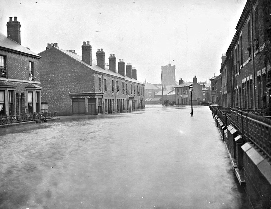
An equally wet Queen Victoria Road looking down towards the Spon Street/Fleet Street Junction. Further up on the Right is Garfield Road, with St. Johns in the background. The shop on the left belonged to W. H. Reading, butcher, on the corner of Croft Road. The house opposite was that of the Widow, Hannah Patrick.
(
Click the image for a larger version.)
This highly engineered work was largely undertaken in the 1960s, and in many ways put the river Sherbourne to bed after centuries of being an essential part of Coventry life. Thankfully, there are plans and schemes in place to rectify this over the coming years which will hopefully boost further tourism and add to the city centre townscape, but could opening up the river also create any potential environmental problems?
Like with the majority of rivers on the living planet, they are liable to flood, and when it comes to the Sherbourne, it's certainly had its fair share over the centuries. Recent major floods of the river had been recorded in the winter of 1794/95; November 1800; November 1852; July 1853, the winter of 1862/63, and another in 1875. However, perhaps its most notable and recorded flooding event, occurred very late on New Years' Eve, 1900, when the average rate of 3.77 inches of rain per hour were recorded over a 24 hour period, the worst downpour happening between midnight and 1am on New Year's Day.
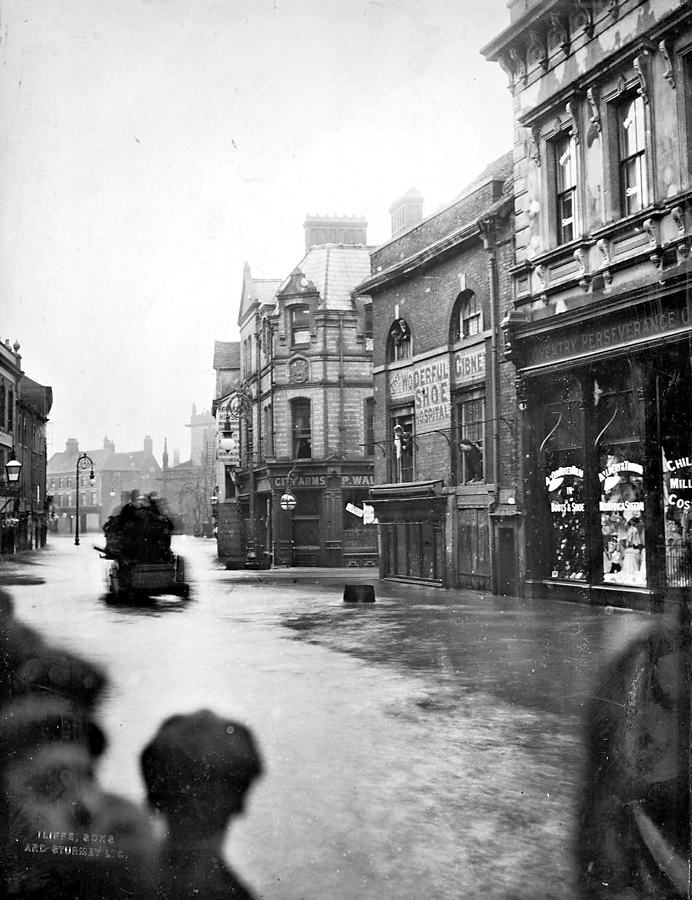
Fleet Street looking towards Spon Street, with West Orchard opening to the right, by the City Arms. The shop opposite belonged to Thomas Gibney, boot repairer, originally of Wolverhampton. Ram Bridge is behind the photographer.
(
Click the image for a larger version.)
People woke up to chaos but still many attempted to go about their usual business. The river had broken its banks at several locations across the town, with Godiva Street being described 'like a river', there being a 'lake in Hales Street', and 'Queen Victoria Road, one long canal'.
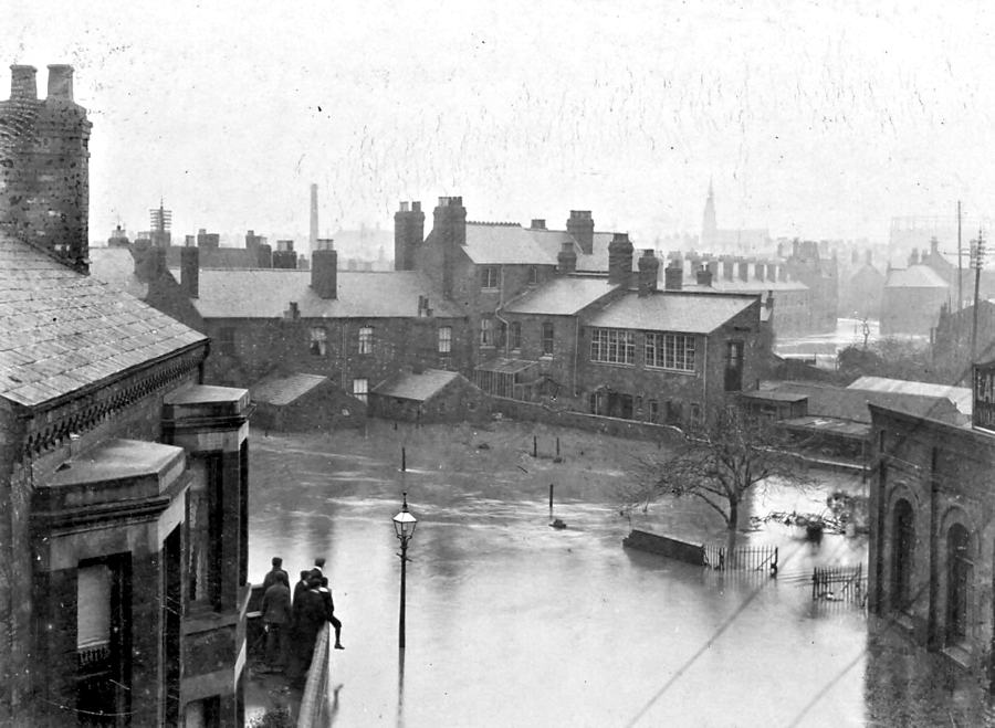
This image was taken from an upper floor window of the Rover Co.'s Meteor Works, Garfield Road, towards the rear of properties on Queen Victoria Road. The Spire of St. Osburg can be seen in the distance. The house on the left with onlookers belonged to the hardware dealer Francis Smith.
(
Click the image for a larger version.)
A 68-year old widower named Joseph Sheward of 4 House, 1 court, Hill Street sadly drowned, whilst trying to escape through his ground floor window. Attempts were desperately made to rescue him but he was sadly swept away by the force of the torrent.
A relief fund was very quickly established, and a full investigation of the flood was readily undertaken by the City Engineer and Surveyor J. E. Swindlehurst, completed around six weeks later with various recommendations, proposals and estimated costs.
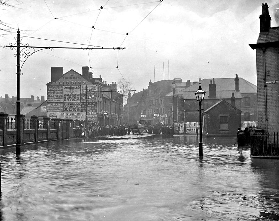
A view up Hales Street taken from in front of the Fire Station, with Chauntry Place to the right and the cattle market on the left. The Hippodrome and Grammar School can be seen in the distance.
(
Click the image for a larger version.)
 f Particular historical interest today however, and the focus of this article, was the 18 bridges named in his report, stretching from Spon End, through the City centre, and back out to the London Road. Considering that most of these bridges are either now lost or unseen, Swindlehurst went into great detail in describing each of the aforementioned, of which I am pleased to share aspects of hopeful interest below:
- Spon End Bridge: a stone bridge of three spans, the sectional area of which was 242 "super" feet, "which is greatly in excess of any bridge on the whole length of the river within the City".
- Hope Street Bridge: Situated 295 yards down from Spon End Bridge, brick built with two inverts measuring 70.6 superficial feet, improved in 1875.
- Crow Lane Bridge: situated a further 295 yards down the river, this was an iron girder bridge with no invert, with a sectional area of 82 super feet.
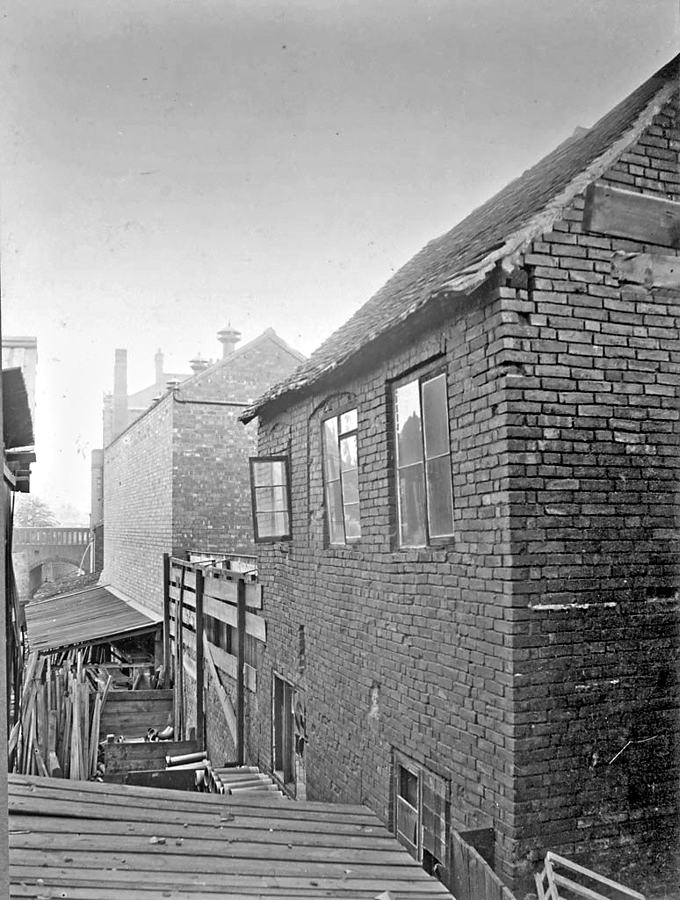
A glimpse of Priory Street Bridge can be seen from these old buildings to the rear of the Triumph cycle factory alongside a timber yard.
(
Click the image for a larger version.)
- Bridge to Rudge Whitworth Works: Small footbridge consisting of a brick arch from Rudge Road, about 50 yards from Crow Lane Bridge, of 63 super feet.
- Queen Victoria Road Bridge: a Brick arched bridge of no invert, 277 yards further down from Crow Lane Bridge, measuring 128 super feet.
- Smithford Street Bridge/Ram Bridge: A Brick arched bridge without invert of 148 super feet, with some buildings supported, 222 yards down from QVR.
- West Orchard Bridge: a two arch stone bridge of 135 super feet, 73 yards down from Ram Bridge, again with some properties being supported.
- West Orchard Chapel Bridge: A brick arched bridge without invert, with a sectional area of 135 super feet, and situated 78 yards down from West Orchard Bridge.
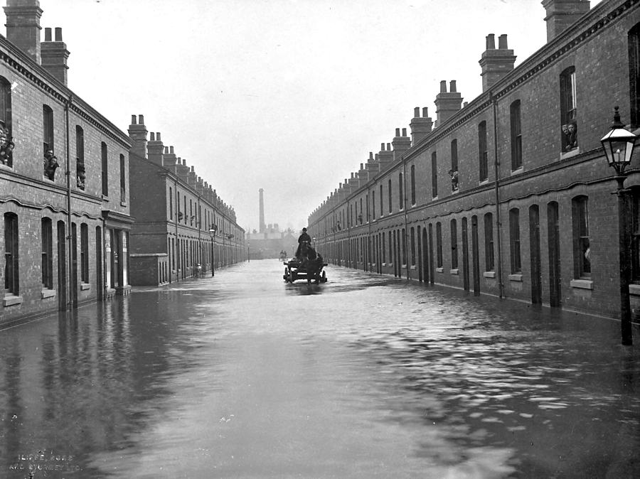
A Rare view of Godiva Street, constructed in 1897/8 but now long gone beneath the post war ring road system. Access to the river could be obtained by the opening on the left-hand side opposite Pettifors', the newsagent and confectioner.
(
Click the image for a larger version.)
- Bridge under Rider Betts & Sons: A Brick arched bridge with no invert of 109 super feet, with an extensive building being supported.
- Bridge under Burges: A single arched brick bridge in three sections, without invert supporting properties on the street above, situated 300 yards down from West Orchard Bridge and measuring 103 super feet.
- Palmer Lane to New Buildings: A portion of the river between these points is oval culverted for a length of 115 yards, and at the Palmer Lane end the river passes under a coach house. It has a sectional area of just 57.5 super feet making it the smallest bridge on the list.
- Priory Street Bridge: a brick bridge without invert situated 197 yards down from New Buildings of 162 super feet.
- Cox Street Bridge: the river is culverted at this point for a length of 87 yards passing under certain buildings and under Cox Street. The sectional area of the culvert is 69 super feet.
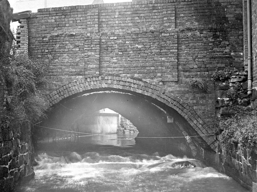
Gosford Street Bridge, taken in 1929 by City Engineer E. H. Ford.
(
Click the image for a larger version.)
- Godiva Street Bridge: constructed of iron girders and without invert, this bridge has a sectional area of 104 super feet and is situated 308 yards down from Cox Street.
- Gosford Street Bridge: extended at various periods, a single arched bridge in three sections of 99 super feet.
- Brickkiln Lane Bridge: a brick arch construction without invert of 118 super feet.
- Bridge to Stables, Charterhouse Mills: another brick arch bridge without invert of 62 super feet.
- Bridge under road to Charterhouse: a two-arch stone bridge of 184 super feet, making it the second largest bridge after Spon End.
The cover of the Swindlehurst Report of February 1901.
Parts of the Sherbourne liable to flooding as showing "ponding" on the west side of Coventry. (
Click image to see a large version.)
And finally an illustration depicting the longitudinal section of the river from Spon End to London Road. (
Click image to see a large version.)
So, next time you are taking a stroll through Coventry City Centre, perhaps attempt to (safely) track the route of the Sherbourne outlined above and see if you can detect any remnants on these lost Bridges.
Damien Kimberley, March 2022


 f you were to walk to modern day Meadow Street in Spon End, Coventry, you will find the exact place that the River Sherbourne is culverted underneath the City Centre. If you then make your way to The Burges and head down Palmer Lane, to your right you will see a Dickensian view of a small section of the River to the rear of the Coventry Cross Pub. If you then continue on to Gosford Street, and enter the path by Gosford Bridge towards Gulson Road, you will see where the river reappears and flows out towards the Charterhouse on the London Road.


 f Particular historical interest today however, and the focus of this article, was the 18 bridges named in his report, stretching from Spon End, through the City centre, and back out to the London Road. Considering that most of these bridges are either now lost or unseen, Swindlehurst went into great detail in describing each of the aforementioned, of which I am pleased to share aspects of hopeful interest below:


